Free Walking Tour San Francisco: Wharf to Ferry Building

From the old fishing docks over Russian Hill and Telegraph Hill, through Chinatown and downtown to the clock tower on the Embarcadero: eight stops, 6.2 km on foot.

8 Stops 6.2 km ~1 h 36 min walking
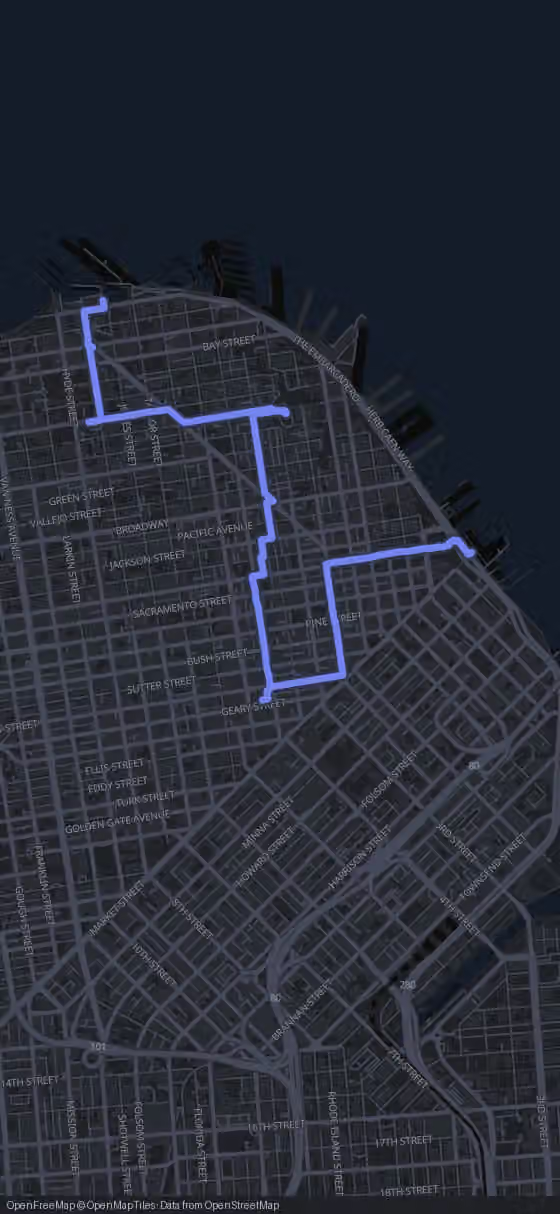
Route map for the San Francisco walking tour
Stop 1 of 8
900 m·11 min
Fisherman's Wharf
Head south from the waterfront toward Lombard Street
Welcome to San Francisco. I'm Alex, and its engineers have spent generations finding unusual ways to tame these hills.
Try this tour with Alex

Where the Route Goes and What It Costs

This route links eight stops over 6.2 km, from Fisherman's Wharf via Lombard Street, Coit Tower, the San Francisco Cable Cars, Chinatown, Union Square and the Transamerica Pyramid to the Ferry Building. Pure walking time is 1 h 36 min; with the visits worth making, plan on about four and a half hours.

Most of it costs nothing: the streets, plazas, waterfront and Ferry Building are free. Coit Tower charges admission inside, and a cable car ride needs a fare. The GPS route runs free in your browser; the AI Tour Guide is optional.

Open free GPS & optional AI Tour Guide
This short shows highlights of the route. All 8 stops follow below.

The Route

Walking Map of San Francisco from the Wharf to the Embarcadero

8 stops 6.2 km 1 h 36 min walking
Tap to load interactive map

The 8 stops along this route

  1. Fisherman's Wharf in San Francisco, stop 1 on the self-guided walking tour
    1Fisherman's Wharf
  2. Lombard Street in San Francisco, stop 2 on the self-guided walking tour
    2Lombard Street
  3. Coit Tower in San Francisco, stop 3 on the self-guided walking tour
    3Coit Tower
  4. San Francisco Cable Cars, stop 4 on the self-guided walking tour
    4San Francisco Cable Cars
  5. Chinatown in San Francisco, stop 5 on the self-guided walking tour
    5Chinatown
  6. Union Square in San Francisco, stop 6 on the self-guided walking tour
    6Union Square
  7. Transamerica Pyramid in San Francisco, stop 7 on the self-guided walking tour
    7Transamerica Pyramid
  8. Ferry Building in San Francisco, stop 8 on the self-guided walking tour
    8Ferry Building
  9. That's the full route.

    Walk it with an AI Tour Guide talking you through every one of these streets.

    Start free in your browser
    You made it

Your San Francisco Walking Tour, Stop by Stop from Pier to Clock Tower

  1. 1

    Fisherman's Wharf

    Fisherman's Wharf in San Francisco, stop 1 on the self-guided walking tour

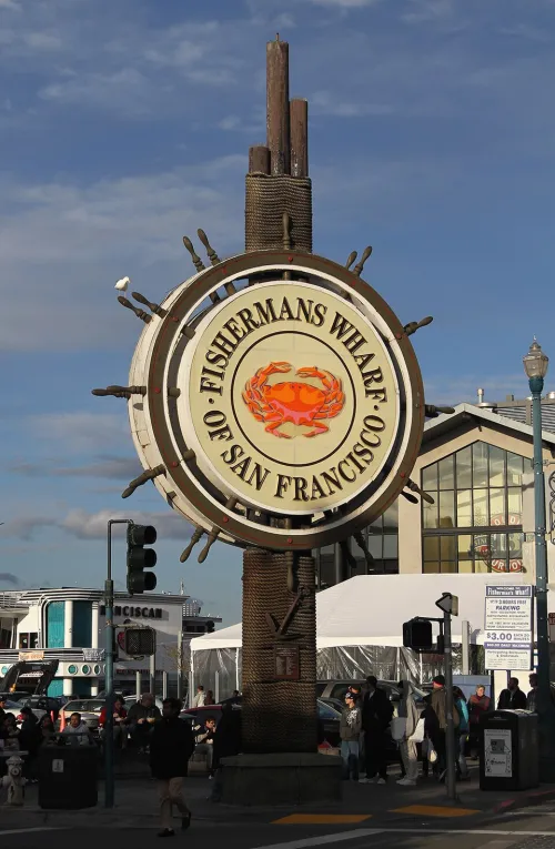
    You start where San Francisco once earned its living from the water. Fisherman's Wharf began as a working fishing port, and its seafood restaurants were drawing outsiders even while the boats still set the rhythm of the day. Look along the docks for working boats: through all the redevelopment of the 1970s and 1980s, many active fishermen and their fleets stayed based here.

    The roots go back to 1884, when the state built its first Fisherman's Wharf at the foot of Union Street, a long, narrow pier about 450 feet long and 150 feet wide, entered from its sheltered eastern side. In 1900 California reserved the waterfront between the foot of Taylor and Leavenworth streets for commercial fishing boats. During the 1960s and 1970s the fishing docks declined, and tourism took over.

    What counts as the Wharf depends on who you ask. In the narrowest sense it is the busy strip along Jefferson Street and the streets around it, plus Pier 39: the part often labeled the tourist trap. More broadly it covers the whole neighborhood north of Bay Street, from Pier 35 west to Hyde Street and Aquatic Park, sometimes as far as Van Ness Avenue, where a high wall separates it from Fort Mason. The local business district even reaches along Beach Street to include Ghirardelli Square.

    Strolling the promenade is free at any hour, so take your time with the boats and the bay. Then leave the water behind and head 860 m, about 15 minutes, into Russian Hill, one of the neighborhoods that lie south of the Wharf.
    Hours
    Open 24/7 (public neighborhood)
    Price
    Free (public waterfront district / promenade)
  2. 2

    Lombard Street

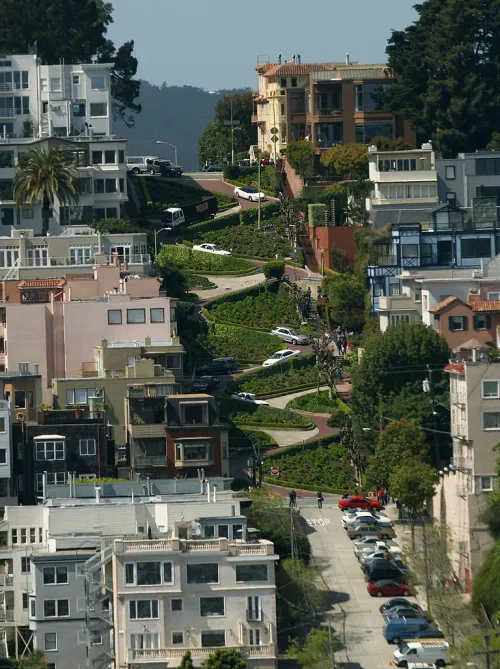
    Lombard Street in San Francisco, stop 2 on the self-guided walking tour

    Here is the block everyone comes for: one short stretch of Lombard Street between Hyde and Leavenworth streets that folds itself into eight hairpin turns. It is paved with red bricks, runs one-way downhill, and a sign at the top recommends 5 mph. Measured along its curves the block is about 600 feet (180 m) long, while a straight line would cover only 412.5 feet.

    The curves were a practical fix. The hill's natural grade of 27 percent was too steep for most vehicles, so property owner Carl Henry suggested the winding design, built in 1922. Whether it truly is the crookedest street in the world, as the claim goes, is up for debate, but the crowds don't mind: around two million visitors a year as of 2015, and up to 17,000 a day on busy summer weekends.

    Watch the cars as much as the curves. Around 250 vehicles an hour wind their way down, and at peak times drivers wait up to 20 minutes to get in, in a queue that can reach back to Van Ness Avenue. On foot you skip all that. At the top, on Hyde Street, the Powell-Hyde cable car stops, so you may see one pull in.

    The name came from surveyor Jasper O'Farrell, who borrowed it from Lombard Street in Philadelphia. The crooked block is a tiny piece of a long road running from the Presidio to the Embarcadero, partly signed as U.S. Route 101. At Telegraph Hill its eastern stretch turns into Telegraph Hill Boulevard, leading to Pioneer Park and Coit Tower, your next stop, 1210 m and about 22 minutes away.

    Hours
    Open 24/7 (public street)
    Price
    Free (public street)
  3. 3

    Coit Tower

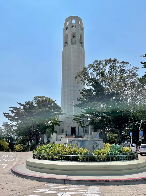
    Coit Tower in San Francisco, stop 3 on the self-guided walking tour

    The slim concrete column on Telegraph Hill rises 210 feet (64 m) from Pioneer Park and overlooks the city and the bay. It went up between 1932 and 1933 in Art Deco style, built of unpainted reinforced concrete to designs by architects Arthur Brown Jr. and Henry Temple Howard. Before you go in, look above the main entrance for the concrete phoenix by sculptor Robert Boardman Howard, commissioned by the architect and cast as part of the building.

    The money came from Lillie Hitchcock Coit, and her will clears up a myth you'll probably hear. She left two bequests: one for a memorial to the city's volunteer firefighters, which became statuary in Washington Square, and one to beautify San Francisco. The tower comes from the second. So it is not a monument to firemen, and its supposed resemblance to a fire hose nozzle is pure coincidence.

    Inside is the reason to pay admission: fresco murals in the style of American Social Realism, painted on site by 22 artists and their many assistants. Three of the artists preferred oil on canvas and worked elsewhere, and one chose egg tempera over fresco, so watch for the differences in surface as you walk around. If you care about art or 1930s America, the ticket is worth it; if you're short on time, the exterior and the phoenix still justify the walk up the hill.

    The tower has been on the National Register of Historic Places since January 29, 2008. From here it's 1090 m, about 16 minutes, to the San Francisco Cable Cars.

    Hours
    Daily 10:00–18:00 (Apr–Oct), 10:00–17:00 (Nov–Mar); ticket sales end 1 hour before closing. Closed Thanksgiving, Christmas Day, New Year's Day.
    Price
    $11 non-resident adults, $8 SF residents, $8 seniors (62+) & youth (12-17), $3 children (5-11), free under 5
  4. 4

    San Francisco Cable Cars

    San Francisco Cable Cars, stop 4 on the self-guided walking tour

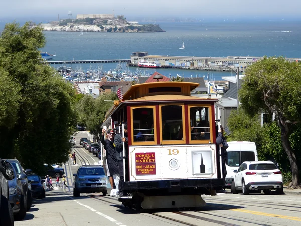
    Here you meet the world's last manually operated cable car system, still running as part of the city's Muni network. Of the 23 cable car lines built between 1873 and 1890, only three survive: two routes from downtown near Union Square to Fisherman's Wharf, and a third along California Street. Watch how the cars move: the grip that takes hold of the running cable is the heart of the whole idea.

    That idea belongs to Andrew Smith Hallidie. In 1869, the story goes, he saw a horsecar slide backwards on wet cobblestones, killing the horses. He raised money in 1871 and 1872, with Henry L. Davis, Joseph Britton and James Moffit as his main backers, and on August 2, 1873, the Clay Street Hill Railroad made its first run. Engineer William Eppelsheimer worked alongside him, and both took out patents. Their grip cars towed trailer cars, and theirs was the first design to use grips at all.

    Today most of the millions of riders each year are visitors, which is why the wait to board can reach two hours or more. A ride costs a fare and isn't needed for this walk, so let your patience decide. The system is listed on the National Register of Historic Places and is one of only two street railways named a National Historic Landmark; the other is the St. Charles Streetcar Line in New Orleans.

    Chinatown starts practically next door: 120 m, about 2 minutes on foot.

    Hours
    Not 24/7: Powell/Hyde cable car runs daily 07:00–23:00; other lines have route-specific hours.
    Price
    USD 9 adult; USD 4 reduced
  5. 5

    Chinatown

    Chinatown in San Francisco, stop 5 on the self-guided walking tour

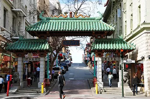
    You're now in the oldest Chinatown in North America and one of the largest Chinese enclaves outside Asia, centered on Grant Avenue and Stockton Street. It's free to wander, and wandering is the point: this is a living neighborhood with its own places of worship, social clubs, languages and customs, not a stage set.

    Chinatown took shape in the early 1850s and has influenced the history and culture of Chinese immigrants across North America ever since. Listen as you walk: the voices are mostly Cantonese and Taishanese, both from southern China, since most residents trace their roots to Guangdong Province and Hong Kong. Mandarin speakers from Taiwan and from central and northern China form a smaller group.

    Officially the district covers 24 square blocks, roughly half a mile long and a quarter mile wide, bounded approximately by Kearny Street, Broadway, Powell Street and Bush Street. It has two hospitals, several parks and squares, numerous churches and its own post office. Many recent immigrants, a lot of them elderly, choose to live here for the affordable housing and the familiar culture. As of 2013, Chinatown drew more visitors each year than the Golden Gate Bridge.

    From Chinatown it's 860 m, about 11 minutes, to Union Square.

    Hours
    Open 24/7 (public neighborhood)
    Price
    Free (public neighborhood)
  6. 6

    Union Square

    Union Square in San Francisco, stop 6 on the self-guided walking tour

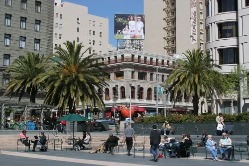
    Union Square is a 2.6-acre plaza framed by Geary, Powell, Post and Stockton streets, and the name also covers the shopping, hotel and theater district around it. In the middle stands the Dewey Monument, 97 feet (30 m) tall, crowned by Nike, the ancient Greek goddess of victory.

    The square began as a large sand dune. In 1850 it was set aside as a public park and dedicated by John Geary, the city's first American mayor. Its name comes from the pro-Union rallies Thomas Starr King held here on the eve of and during the Civil War, which earned it status as a California Historical Landmark.

    The monument was dedicated in 1903 to Admiral George Dewey's victory at the Battle of Manila Bay in the Spanish-American War, and it also honors the recently assassinated President William McKinley and the sailors of the U.S. Navy. Sculptor Robert Aitken modeled the figure of Victory on Alma de Bretteville, a Danish-American stenographer and artist's model who later married one of San Francisco's richest citizens. Look up, and you're looking at her.

    For decades the blocks around the plaza held one of the largest collections of department stores, upscale boutiques, galleries and salons in the country. The COVID-19 pandemic drove many companies out of downtown and hit this retail district hard. Next comes the walk into the Financial District: 1220 m, about 17 minutes, to the Transamerica Pyramid.

    Hours
    Open 24/7 (public space)
    Price
    Free (public plaza)
  7. 7

    Transamerica Pyramid

    Transamerica Pyramid in San Francisco, stop 7 on the self-guided walking tour

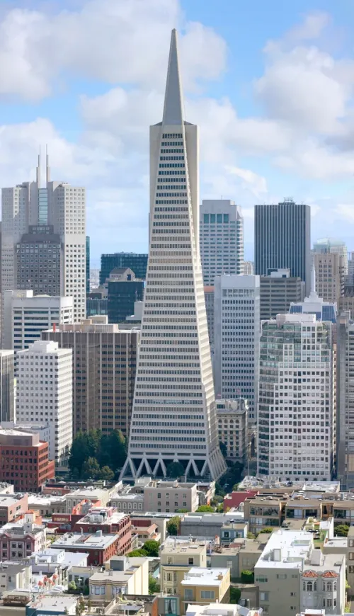
    You'll recognize it long before you reach 600 Montgomery Street: a 48-story pyramid rising 853 feet (260 m), locally nicknamed Big Pointy. Architects William Pereira and Harry D. Som designed it, and when it was completed in 1972 it was the eighth tallest building in the world. It remained the tallest in San Francisco until 2017 and is now the second tallest on the skyline.

    The company that gave it its name has moved its U.S. headquarters to Baltimore, yet the pyramid still appears in the Transamerica logo. Ownership has changed too: in 2020 New York investor Michael Shvo bought it and in 2022 hired Norman Foster to redesign and renovate the interiors, and as of April 2026 it belongs to Yoda PLC, a Cyprus-based investment firm led by Ioannis Papalekas.

    The ground beneath holds older stories. The tower stands on reclaimed land at what was once the shoreline of Yerba Buena Cove, where the Mexican pueblo of Yerba Buena was founded in 1834. In 1846, during the Mexican-American War, a detachment from the USS Portsmouth landed here and raised the American flag at today's Portsmouth Square. In 1853 the Montgomery Block rose on this site and for over 100 years housed offices and apartments for well-known financiers, lawyers and artists, until it was torn down in 1959 for a parking lot.

    The exterior and Transamerica Redwood Park are free. As you set off for the Ferry Building, 840 m and about 12 minutes away, the Redwood Grove at the pyramid makes a quiet first pause.

    Hours
    Exterior: 24/7; Transamerica Redwood Park: daily sunrise to sunset
    Price
    Free (exterior and Redwood Park)
  8. 8

    Ferry Building

    Ferry Building in San Francisco, stop 8 on the self-guided walking tour

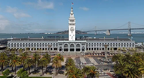
    The walk ends where the city meets the bay. Above the Ferry Building rises a 245-foot (75 m) clock tower with four dials, each 22 feet (6.7 m) across, visible from Market Street. Architect A. Page Brown designed it in 1892 in the Beaux-Arts style, possibly inspired by the Giralda bell tower in Seville, and it was completed in 1898 as the largest project the city had undertaken up to then. Notice the arched arcade running the full length of both fronts.

    It is still a working terminal, served by Golden Gate Ferry and San Francisco Bay Ferry routes. Its quiet decades came after the 1950s, when bridges took over transbay traffic and most streetcar routes became buses; the building was turned into offices and its public spaces were broken up.

    A restoration beginning in 2002 brought it back. The 660-foot (200 m) Great Nave regained its height and materials, the former baggage handling area on the ground floor became a marketplace and food hall, and the upper floors went to offices and the Port Commission. Entry is free, and on certain days a farmers market joins the marketplace.

    Listen on the hour: during daylight the bell chimes portions of the Westminster Quarters. The building is a designated San Francisco landmark and listed on the National Register of Historic Places. If your trip continues, you can walk Los Angeles or San Diego the same way.

    Hours
    Daily 06:00–22:00 (Marketplace building); Farmers Market: Tue & Thu 10:00–14:00, Sat 08:00–14:00. Closed Thanksgiving and Christmas Day.
    Price
    Free (public building / marketplace entry)
Walking tour route map of San Francisco Route loaded
Fisherman's WharfLombard StreetCoit TowerSan Francisco Cable Cars+4
All 8 stops are already on the map.
You just press start.
AI Tour Guide

You've read the way from the Wharf to the Ferry Building. Now walk it with a guide in your ear.

Press start wherever you are, even hundreds of kilometres from San Francisco, and the guide begins telling its stories right away. In the city, pick any of the 8 stops to start from: it leads you there, then talks with you the whole route, asking, listening, remembering, and shaping the tour around your answers.

8stops 6.2km 1 h 36 minwalking 13languages
▶Start the tour free

Free to start · Runs in your browser · No app, no download

Shorter Ways to Walk the City

Not every day has room for the full route. These cuts follow the same order and keep the legs as they are.

Wharf and the two hills

Stops: 1, 2, 3

For anyone who wants the classic picture: the waterfront, the crooked block and the tower on Telegraph Hill. Walking time is 37 minutes; the only admission is Coit Tower, if you go inside for the murals.

Downtown half

Stops: 4, 5, 6, 7, 8

Good if you're staying downtown or arriving late in the day: cable cars, Chinatown, Union Square, the pyramid and the Ferry Building. Walking time is 42 minutes. Everything is free unless you decide to ride a cable car.

Full route, outside only

Stops: 1, 2, 3, 4, 5, 6, 7, 8

For tight budgets: all eight stops in 1 h 36 min of walking, skipping the Coit Tower interior and the cable car ride. Then the whole day costs nothing.

How Long This San Francisco Tour Takes, With and Without the Coit Tower Murals

The legs are short: the longest runs 1220 m from Union Square to the Transamerica Pyramid, and the hop from the cable cars into Chinatown takes just 2 minutes. That keeps the pure walking time at 1 h 36 min.

Most of the extra time goes into three places: about 45 minutes for the murals inside Coit Tower and half an hour each for Chinatown and the Ferry Building. Add shorter pauses at the Wharf, Lombard Street, Union Square and the pyramid, and you arrive at the four and a half hours. A cable car ride, with its wait, comes on top.

The hill variant fills about two hours, the downtown half about two and a half, and the full route seen only from outside about three hours.

Before You Set Off from the Wharf

  • Start: Fisherman's Wharf is the recommended start, but you can join at any stop and pick up the route from there.
  • Finish: The Ferry Building on the Embarcadero, a working ferry terminal.
  • Timing: Plan your start so you reach Coit Tower while tickets are still sold; sales stop before closing time, so check the hours on the day.
  • Admission: Only the Coit Tower interior charges admission, and a cable car ride needs a fare. The Wharf, Lombard Street, Chinatown, Union Square, the pyramid's exterior and the Ferry Building are free.
Walking tour route map of San Francisco
AI Tour Guide

Your guide is ready at the Wharf, or wherever you join.

Press start and a voice AI Tour Guide takes it from here: leading the route through San Francisco, telling the stories, and turning your walk into a real back-and-forth conversation. No app or download is needed; it runs in your browser.

8stops 6.2km 1 h 36 minwalking 13languages
▶Start the tour free

Free to start · Runs in your browser · No app, no download

What the AI Tour Guide Adds Between the Bay and the Hills

The free GPS route leads you from stop to stop; the AI Tour Guide turns the walk into a conversation. It greets you, tells the stories of each place, asks what you'd like more of and remembers it. Linger over who Lillie Hitchcock Coit really was, what the individual Coit Tower murals show, or how the financiers and artists of the Montgomery Block lived, and it follows your lead; you can interrupt at any time. You start with 100 free credits, then choose this tour all-inclusive for €19.99 with no time limit, or €5 per hour.

A Real Conversation A voice AI Tour Guide greets you, leads the whole route, and tells the stories and facts as you walk, asking what you want to see and keeping a real conversation going. Not a recording you press play on.
Map Navigation Follow the route on the map and walk at your own pace. You choose where to start and when to move to the next stop.
Ask Anything Curious about a building you pass? Ask your AI Tour Guide on the spot and the conversation carries on.
13 Languages Switch language anytime. No separate tour needed.
Start free in your browser

Common Questions About Walking San Francisco

Are the Golden Gate Bridge and Alcatraz on this walk?

No. The route stays between the northern waterfront and downtown, from Fisherman's Wharf to the Ferry Building. Plan the bridge and the island as separate outings.

Is the cable car fare part of the tour?

No. The cable cars are run by the city's Muni network, and you pay the fare to them. The walk works fine without riding at all.

Can I walk the route in reverse, starting at the Ferry Building?

Yes. The legs stay the same length; only the order flips. The order shown is the recommended one, but every stop works as a starting point.

Can I continue across the bay by ferry at the end?

The Ferry Building is still an active terminal, served by Golden Gate Ferry and San Francisco Bay Ferry routes. Check destinations and departures at the terminal.

Is the tour really free?

Yes. The whole tour is free: the route, the interactive map and the navigation cost you nothing. Only the voice AI Tour Guide is optional and paid: you test it with 100 free credits, then you pay either €5 per hour or €19.99 for this whole tour, with no time limit. Admission to 2 of the 8 stops is not included: Coit Tower and San Francisco Cable Cars charge their own entry fees.

Do I need to download an app?

No. Everything runs in your phone browser. Open the route and start walking, no download and no sign-up required.

Do I need to book the walking tour in advance?

No booking needed. This self-guided tour is available anytime. Open the route in your browser and start walking. The AI Tour Guide works instantly, no app, no reservation required.

What languages is the AI Tour Guide available in?

The AI Tour Guide speaks 13 languages, so you take the tour in your own language and can switch at any time.

Can I skip stops or change the route?

Yes. Skip any stop, spend extra time at places you like, or start the route from any point. It is your walk, you set the pace.
Image credits
▶ Start free in your browser Runs in your browser, no app, no download