Free Walking Tour Boston: Parks, River and Revolution

Fourteen stops from the brick sidewalks of Beacon Hill along the Charles to Bunker Hill and the North End, where two lanterns warned the Patriots in 1775.

14 Stops 11.8 km ~2 h 49 min walking
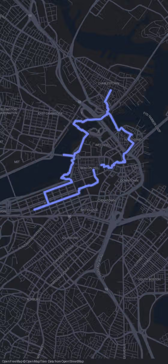
Route map for the Boston walking tour
Stop 1 of 14
320 m·4 min
Beacon Hill
Head south from Beacon Hill down toward Boston Common
Welcome to Boston. I'm Alex, and our first story begins with windows that slowly changed colour in the sun.
Try this tour with Alex

What the Boston Walk Covers

This free walking tour of Boston links 14 stops over 11.8 km, from Beacon Hill through the parks, Back Bay and the riverbank to Charlestown and the North End, ending at the Massachusetts State House. Pure walking time is 2 h 49 min; with short visits, plan about six hours.

Most stops are free, including Faneuil Hall and the State House. Only the Old North Church and the Museum of Science charge entry. Route, map and GPS navigation are free in your browser; the AI Tour Guide is optional.

Open free GPS & optional AI Tour Guide
This short shows highlights of the route. All 14 stops follow below.

The Route

Boston Walking Map from Beacon Hill to the North End

14 stops 11.8 km 2 h 49 min walking
Tap to load interactive map

The 14 stops along this route

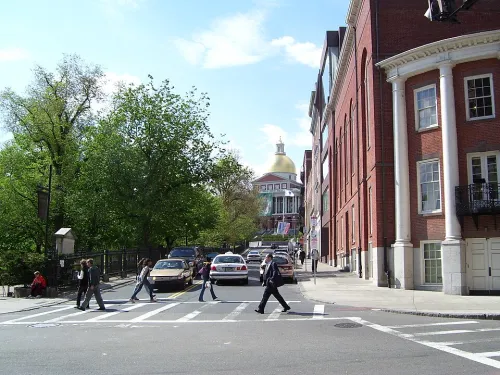
  1. Beacon Hill in Boston, stop 1 on the self-guided walking tour
    1Beacon Hill
  2. Boston Common, stop 2 on the self-guided walking tour
    2Boston Common
  3. Boston Public Garden, stop 3 on the self-guided walking tour
    3Boston Public Garden
  4. Newbury Street in Boston, stop 4 on the self-guided walking tour
    4Newbury Street
  5. Back Bay in Boston, stop 5 on the self-guided walking tour
    5Back Bay
  6. Charles River Esplanade in Boston, stop 6 on the self-guided walking tour
    6Charles River Esplanade
  7. Cambridge Bridge in Boston, stop 7 on the self-guided walking tour
    7Cambridge Bridge
  8. Museum of Science in Boston, stop 8 on the self-guided walking tour
    8Museum of Science
  9. Bunker Hill Monument in Boston, stop 9 on the self-guided walking tour
    9Bunker Hill Monument
  10. Old North Church in Boston, stop 10 on the self-guided walking tour
    10Old North Church
  11. North End in Boston, stop 11 on the self-guided walking tour
    11North End
  12. Faneuil Hall in Boston, stop 12 on the self-guided walking tour
    12Faneuil Hall
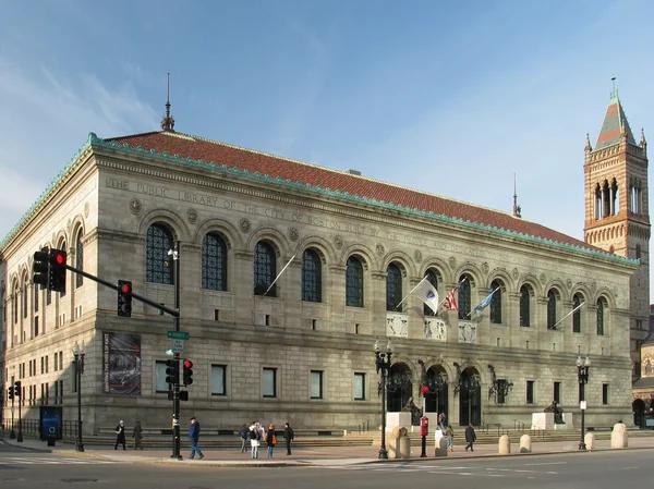
  13. Boston Public Library, stop 13 on the self-guided walking tour
    13Boston Public Library
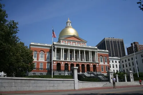
  14. Massachusetts State House in Boston, stop 14 on the self-guided walking tour
    14Massachusetts State House
  15. That's the full route.

    Walk it with an AI Tour Guide talking you through every one of these streets.

    Start free in your browser
    You made it

The Boston Walking Tour in 14 Stops

  1. 1

    Beacon Hill

    Beacon Hill in Boston, stop 1 on the self-guided walking tour

    You begin among the Federal-style rowhouses of Beacon Hill, where narrow streets and brick sidewalks set the tone for the morning. This was the stronghold of Boston's old-money Brahmin families, and it is still counted among the city's most desirable and expensive neighborhoods. Take your time with the doorways, the even brick fronts and the modest scale of the houses: the whole quarter was laid out in the early 1800s.

    The name comes from a beacon that once stood on the highest point in central Boston, ready to warn residents of an invasion. There used to be three hills here, Beacon Hill, Pemberton Hill and Mount Vernon, and that trio gave the town its early nickname, Trimount, which survives as Tremont Street. Between 1807 and 1832 Beacon Hill itself was cut down from 138 feet to 80 feet, and the other two were leveled entirely.

    All that earth went into the water. The shoreline and the old Mill Pond were filled on a massive scale, increasing Boston's land by 150 percent, and Charles Street was one of the new roads created in the process. Today the neighborhood has three parts: the south slope, the north slope and the Flat of the Hill, a level patch built on that landfill west of Charles Street.

    Locals also use 'Beacon Hill' to mean the state government, much as Washington's Capitol Hill stands for Congress, because the Massachusetts State House sits up here. You will come back to it at the very end. For now, head 440 m, about six minutes, to Boston Common.
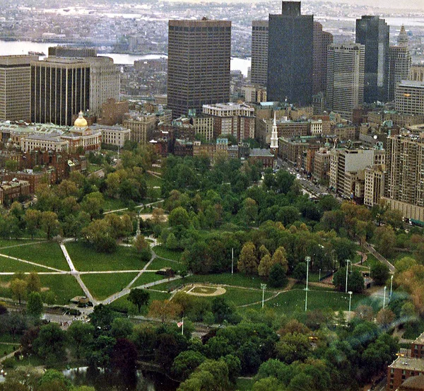
    Hours
    Open 24/7
    Price
    Free
  2. 2

    Boston Common

    Boston Common, stop 2 on the self-guided walking tour

    Boston Common is the oldest city park in the United States: 50 acres of open ground framed by Tremont, Park, Beacon, Charles and Boylston Streets. It is free, open daily from early morning until late evening, and on the Tremont Street side you will find the city's visitor center if you want maps or local advice.

    The story of this land starts with one man. William Blaxton came to the Massachusetts Bay Colony as chaplain of an expedition that landed in Weymouth in 1623. When the others sailed home, he moved five miles north to the Shawmut Peninsula, then a rocky bulge surrounded by mudflats, and lived there entirely alone for five years.

    In 1630 Blaxton wrote to a group of Puritans led by Isaac Johnson, whose settlement in Charlestown was failing for lack of fresh water. He praised the springs of his peninsula and invited them over; they arrived on September 7, 1630. Johnson died less than three weeks later, and Blaxton secured a grant of 50 acres around his home from Governor John Winthrop, about a tenth of the peninsula.

    On the Boylston Street side lies the Central Burying Ground, worth a few quiet minutes. The painter Gilbert Stuart and the composer William Billings are buried here, as are Samuel Sprague, who took part in the Boston Tea Party and fought in the Revolutionary War, and his son Charles, one of America's earliest poets. The Common became a Boston Landmark in 1977. The Public Garden is right next door, 370 m or five minutes on foot.

    Hours
    Daily 06:00–23:30
    Price
    Free
  3. 3

    Boston Public Garden

    Boston Public Garden, stop 3 on the self-guided walking tour

    Where the Common is wide open ground, the Public Garden is planted and tended: it was the first public botanical garden in America, founded in 1837. Entry is free and it keeps the same long daily hours as the Common, so it works just as well for an early stroll as for a late one.

    None of this was land two centuries ago. The whole area was mudflat, and this patch was the first to be filled. In 1794, after a fire destroyed the ropewalks in a busier part of town, Boston let ropemakers use the site, on condition that they build a seawall and fill the ground. Much of that fill came from Mount Vernon on Beacon Hill, first by handcart, then from 1804 on a gravity railroad that ran material down from the hilltop. Mount Vernon no longer exists; you are partly standing on it.

    In February 1824 the city bought the land back for $50,000. A year later someone proposed turning it into a graveyard, and voters rejected the idea by 1632 to 176. In 1837 the philanthropist Horace Gray petitioned to use the land as a botanical garden, and by 1839 his corporation was chartered to create it. Even then, the pressure to sell the ground for new houses never let up.

    From here the walk leaves the old town for land that was reclaimed later. It is 1380 m, about 19 minutes, to Newbury Street in Back Bay.

    Hours
    Daily 06:00–23:30
    Price
    Free
  4. 4

    Newbury Street

    Newbury Street in Boston, stop 4 on the self-guided walking tour

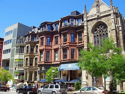
    Newbury Street runs from the Public Garden out to Brookline Avenue, and its best part is the mile east of Massachusetts Avenue: 19th-century brownstones, renovated and filled with hundreds of shops, cafés and restaurants. It is free to wander and open around the clock, which makes it a good place to slow down after the parks.

    Watch how the street changes as the house numbers climb. The high-end boutiques cluster at the Public Garden end, and that concentration of luxury stores has earned Newbury Street a place among the most expensive streets in the world. Further along, the shops get a little cheaper and more bohemian, all the way to Massachusetts Avenue.

    The architect Donlyn Lyndon, a professor at Berkeley, singled out the stretch west of Clarendon Street, where the street develops its own character. Look for the renovated town houses with large glass bays on the ground floor: they turn private homes into shopfronts without losing the rhythm of the brownstone row.

    Beyond Massachusetts Avenue the street changes completely, with the turnpike on one side and service entrances on the other, so there is no need to walk that far. Back Bay, the neighborhood around you, is the next stop, 490 m or about seven minutes away.

    Hours
    Open 24/7
    Price
    Free
  5. 5

    Back Bay

    Back Bay in Boston, stop 5 on the self-guided walking tour

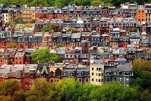
    Back Bay was once exactly that: a tidal bay behind the Shawmut Peninsula, where the water rose and fell several feet a day and much of the bed lay exposed as marsh at low tide. Construction on the reclaimed land began in 1859, driven by demand for luxury housing, and by around 1900 the neighborhood was complete.

    What you see is its signature: rows of Victorian brownstones, regarded as one of the best-preserved examples of 19th-century urban design in the United States. Back Bay was planned as a purely residential district; offices and shops were allowed only from around 1890. Today the John Hancock Tower, Boston's tallest skyscraper, rises among the old rows, and the Boston Public Library and the Boston Architectural College have their homes here.

    The human story here goes back much further than the brownstones. Around 5,200 years ago, Native Americans built fish weirs in the bay, and traces of them turned up in 1913 during subway construction. In 1814 the Boston and Roxbury Mill Corporation was chartered to build a milldam across the water, which doubled as a toll road to Watertown and set the stage for the later filling.

    Back Bay rewards aimless walking more than any single address, and it costs nothing. When you are ready, head 1380 m, about 20 minutes, to the Charles River Esplanade.

    Hours
    Open 24/7
    Price
    Free
  6. 6

    Charles River Esplanade

    Charles River Esplanade in Boston, stop 6 on the self-guided walking tour

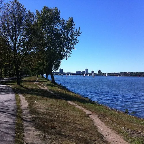
    The Esplanade is a state-owned park on the south bank of the Charles River Basin, with walkways, statues, playgrounds, ballfields and Community Boating along the water. It is free and open from dawn to dusk, so time this part of the walk for daylight.

    It began in 1910 as the Boston Embankment, built together with the Charles River Dam Bridge, the site where the Museum of Science stands today. The first version was widely criticized for its lack of shade trees, refreshment stands, recreation and visitors. Trees, a refreshment pavilion and concerts were added in response.

    The real transformation came between 1928 and 1936, helped by a $1 million donation from Helen Osborne Storrow in memory of her husband James. Arthur Shurcliff designed the Storrow Memorial Embankment, adding the first lagoon, boat landings, plazas, playgrounds and the Music Oval. In the summer of 1929 Arthur Fiedler and the Boston Pops played here for the first time, and in 1941 the Hatch Memorial Shell gave them a permanent stage.

    The Esplanade became a Boston Landmark in 2009. Follow the riverbank for 1120 m, about 16 minutes, to the Cambridge Bridge.

    Hours
    Daily dawn-dusk
    Price
    Free
  7. 7

    Cambridge Bridge

    Cambridge Bridge in Boston, stop 7 on the self-guided walking tour

    The Cambridge Bridge, today known as the Longfellow Bridge, links Beacon Hill with Kendall Square in Cambridge. It carries cars, cyclists, pedestrians and the Red Line subway, around 28,600 cars and 90,000 transit passengers every weekday. Walking onto it is free at any hour, and the view of the Boston skyline from here is the reason to come.

    Look at the two large central piers. Their four carved stone towers, whose shape earned the nickname Salt-and-Pepper Bridge, carry the prows of Viking ships cut in granite. They refer to a supposed voyage by Leif Eriksson up the Charles River around the year 1000, a theory promoted at the time by the Harvard professor Eben Horsford. The city seals of Boston and Cambridge decorate the piers too.

    The structure itself is a steel arch bridge: eleven arches resting on ten masonry piers and two massive abutments, growing from about 31 m at the ends to 57 m in the middle. Including approaches it is nearly half a mile long. Its predecessor was the West Boston Bridge, a name Boston kept using officially for the new one.

    Even the Boston Globe praised the view of the city from a Red Line train crossing here. From the bridge it is 1320 m, about 19 minutes, to the Museum of Science; on the way you may pass the Boston Duck Tour.

    Local name
    Longfellow Bridge
    Hours
    Open 24/7
    Price
    Free
    Website
    nps.gov ↗
  8. 8

    Museum of Science

    Museum of Science in Boston, stop 8 on the self-guided walking tour

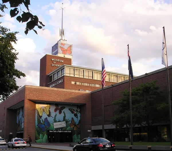
    The Museum of Science spans the Charles River on land shared by Boston and Cambridge. Inside are more than 700 interactive exhibits, live presentations throughout the day, the Charles Hayden Planetarium, the Mugar Omni Theater, New England's only domed IMAX theater, and over 100 animals, since the museum is also an accredited zoo.

    Is it worth the stop? For families and science fans, yes, but it is a half-day commitment, not a quick look, and entry is paid. On the full route, most walkers will admire it from outside and come back another day.

    The museum's roots go back to February 9, 1830, when seven men met to found the Boston Society of Natural History to share their scientific interests. In 1862 the society moved into its own neoclassical building in Back Bay, designed by William G. Preston right next to the original MIT building. MIT's building was demolished in 1939; the old museum still stands, now a home furnishings showroom you may have walked past earlier.

    From here the walk leaves the river for Charlestown. It is the longest leg of the day, 1880 m or about 28 minutes, to the Bunker Hill Monument.

    Hours
    Daily 09:00–17:00
    Price
    33 USD full, 29 USD senior (60+), 28 USD child (3-11), under 3 free
    Website
    mos.org ↗
  9. 9

    Bunker Hill Monument

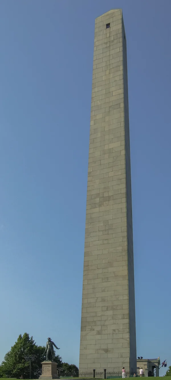
    Bunker Hill Monument in Boston, stop 9 on the self-guided walking tour

    The granite obelisk rises 221 feet, 67 m, from the middle of Monument Square in Charlestown. It marks the Battle of Bunker Hill, a major battle of the Revolutionary War fought here on June 17, 1775. Despite the name, the monument actually stands on Breed's Hill. A statue of the colonial commander William Prescott by William Wetmore Story faces the obelisk, with the entrance building on the other side.

    Entry is free, and you can go up inside the obelisk. Even if you skip that, the square and the statue are worth a slow lap.

    The first memorial here, dedicated in 1794, honored Joseph Warren, an American soldier killed in the battle. When the site was put up for sale in 1822, the Bunker Hill Monument Association formed to save it. Solomon Willard took over the design, the cornerstone was laid in 1825, and then the money ran out: work stopped twice for long periods between 1829 and 1840. The monument was finally dedicated on June 17, 1843, exactly 68 years after the battle, and at that time it was the largest war memorial obelisk in the country.

    The Prescott statue came in 1881 and the granite entrance building in 1902. Since 1976 the National Park Service has managed the site. Next comes a 1620 m walk, about 23 minutes, back toward the old town and the Old North Church.

    Hours
    Daily 10:00–17:00 (last climb 16:30)
    Price
    Free
    Website
    nps.gov ↗
  10. 10

    Old North Church

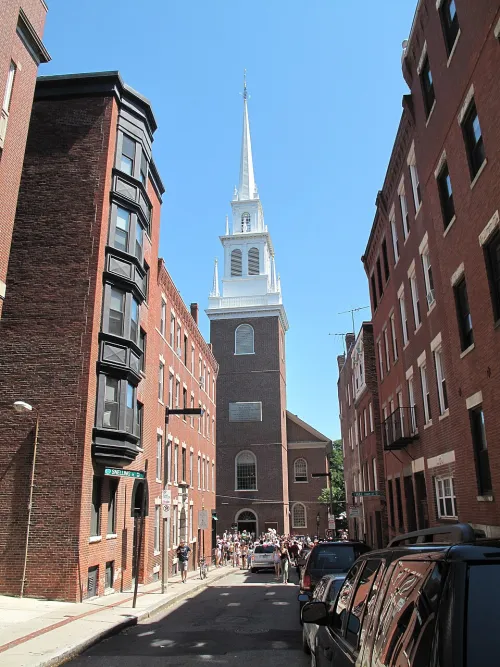
    Old North Church in Boston, stop 10 on the self-guided walking tour

    Officially Christ Church in the City of Boston, the Old North Church on Salem Street was built in 1723 and is the oldest standing church in the city. On the night of April 18, 1775, two lanterns were lit in its steeple to warn the Patriots of British troop movements, the signal that launched Paul Revere's midnight ride.

    Going inside is worth it if the Revolution interests you. Admission is paid, with reduced tickets for younger visitors and free entry for small children. Inside you will see two levels of pews, an organ, a pulpit and ceiling murals; the congregation still holds services here, while the nonprofit Old North Illuminated looks after visitors and preservation.

    The Georgian design was likely inspired by Christopher Wren's churches in London: a rectangular nave, a tower at one end and a rounded apse at the other. The belfry holds eight change-ringing bells cast in 1744, the oldest in North America, and the steeple rises 191 feet, 58 m. It is not the original: steeples were replaced in the 1800s and again in 1955.

    The church itself was closed from 1775 until 1778, during the war. Today it is a National Historic Landmark. The North End begins practically at the door, just 210 m or three minutes away.

    Hours
    Mon–Sat 10:00–17:00, Sun 12:30–17:00
    Price
    10 USD full, 5 USD youth (6-17), under 6 free
  11. 11

    North End

    North End in Boston, stop 11 on the self-guided walking tour

    The North End is Boston's oldest residential neighborhood, settled since the 1630s, and it packs nearly a hundred establishments and plenty of sights into just 0.36 square miles. Today it is known for its Italian American community and its Italian restaurants, so this is a natural place to linger.

    Its history is thick with names. By 1649 the area had enough people to support the North Meeting House, and North Square grew up around it as the center of community life. The minister, Increase Mather, was an influential figure who drew residents here. On November 27, 1676, a fire destroyed his home, the meeting house and 45 buildings in total; two years later Boston organized the first paid fire department in America. The Paul Revere House was later built on the site of Mather's house.

    Look out for Copp's Hill Burying Ground, where the oldest grave markers date from 1661, and for two brick townhouses from the 18th century, when the North End was a fashionable address shared by wealthy families and craftsmen: the Pierce-Hichborn House and the Clough House on Unity Street. After the war, some loyalist residents left for England or Canada.

    Tempers ran high here before the Revolution, too. On the evening of August 26, 1765, rioters protesting the Stamp Act attacked the Hutchinson Mansion on North Square, and Lieutenant Governor Thomas Hutchinson had to flee through his garden. From the North End it is 710 m, about ten minutes, to Faneuil Hall.

    Hours
    Open 24/7
    Price
    Free
  12. 12

    Faneuil Hall

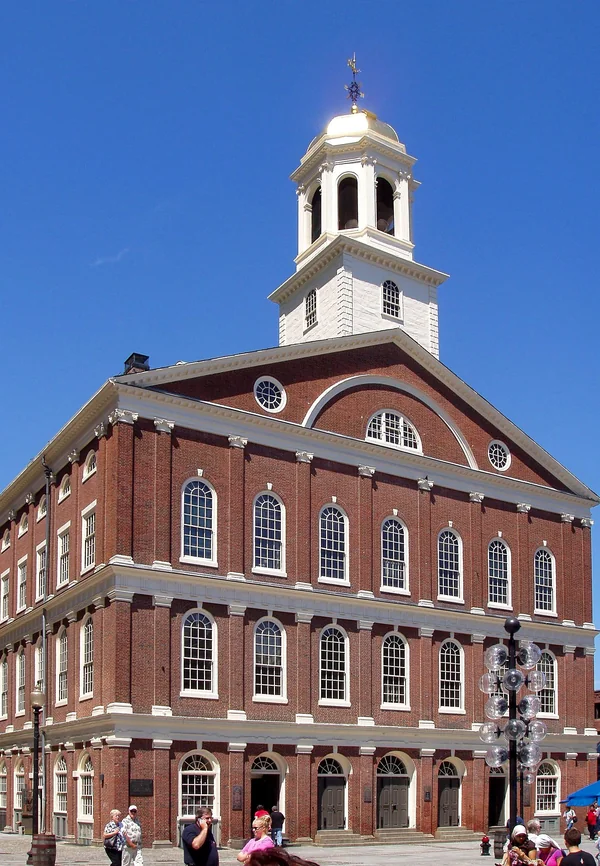
    Faneuil Hall in Boston, stop 12 on the self-guided walking tour

    Faneuil Hall opened in 1742 as a marketplace with a meeting hall above, designed by the artist John Smibert. So many speeches and debates took place here that it earned the nickname 'the Cradle of Liberty'. It is free to enter.

    From outside, look at the red brick, the arched windows and the slate roof with its cupola. On top sits a weathervane shaped like a grasshopper, easy to miss if you do not look for it. The ground floor is still a market area, while the Great Hall on the upper floors is 28 feet high and hung with artwork; it is the room people come to see.

    The original building burned down in 1761 and was rebuilt over the following decade. In 1806 Charles Bulfinch remodeled and expanded it, and it was renovated again in 1827 after Quincy Market opened nearby. The interiors were rebuilt in fireproof materials at the end of the 1890s, and restorations have continued ever since. Faneuil Hall belongs to the city and is a National Historic Landmark.

    From here the Boston Public Library is only 230 m, about four minutes, away; on this short stretch you are walking along part of the Freedom Trail.

    Hours
    Mon–Sat 10:00–21:00, Sun 11:00–19:00
    Price
    Free
  13. 13

    Boston Public Library

    Boston Public Library, stop 13 on the self-guided walking tour

    Founded in 1848, the Boston Public Library holds around 24 million items, making it the third-largest public library in the United States after the Library of Congress and the New York Public Library. It also serves as Massachusetts' Library for the Commonwealth: every adult resident of the state can borrow and do research here.

    Entry is free. A short visit makes a calm break near the end of a long walk.

    What makes the library special is the depth of its research collection: more than 1.7 million rare books and manuscripts, and collections of distinction on Boston history, the Civil War and Irish history. It is one of only two public libraries in the Association of Research Libraries, alongside New York's, and it is also a depository for federal and state government documents. Its Central Library in Copley Square became a Boston Landmark in 2000.

    The last leg is 600 m, about nine minutes, up to the Massachusetts State House.

    Hours
    Mon–Thu 09:00–20:00, Fri–Sat 09:00–17:00, Sun 11:00–17:00
    Price
    Free
    Website
    bpl.org ↗
  14. 14

    Massachusetts State House

    Massachusetts State House in Boston, stop 14 on the self-guided walking tour

    The walk ends where Massachusetts is governed. The State House holds the state legislature, the General Court, and the governor's offices, and it is one of the oldest state capitols still in use. Charles Bulfinch designed it, the same architect who expanded Faneuil Hall, and it is considered a masterpiece of Federal architecture.

    Entry is free. If you find it open when you arrive, going inside is a fitting last visit, tying together the Revolution you have just walked through and the city that came after.

    The building has a story of its own. Paul Revere, then Grand Master of the Grand Lodge of Massachusetts, presided over the Masonic cornerstone ceremony on July 4, 1795. It was completed in January 1798 at a cost of $133,333, more than five times the budget. Bulfinch borrowed from two London buildings, Somerset House and the Pantheon, and after Maine became a separate state in 1820 he used this design as a model for Maine's capitol. Before 1798 the government sat in the Old State House on today's Washington Street.

    The State House kept growing: a major expansion by Charles Brigham was completed in 1895, and the east and west wings followed in 1917. The ground around it was once pasture belonging to John Hancock, the state's first elected governor, and in 2016 a plan to sell a strip of the lawn to a neighboring development led lawmakers to protect the surroundings as open space. With that, you are back on Beacon Hill, where the walk began.

    Hours
    Mon–Fri 08:45–17:00, Sat–Sun closed
    Price
    Free
Walking tour route map of Boston Route loaded
Beacon HillBoston CommonBoston Public GardenNewbury Street+10
All 14 stops are already on the map.
You just press start.
AI Tour Guide

You know the route now. Walk it with a guide talking you through Boston.

Press start wherever you are, even hundreds of kilometres from Boston, and the guide begins telling its stories right away. In the city, pick any of the 14 stops to start from: it leads you there, then talks with you the whole route, asking, listening, remembering, and shaping the tour around your answers.

14stops 11.8km 2 h 49 minwalking 13languages
▶Start the tour free

Free to start · Runs in your browser · No app, no download

Shorter Ways to Walk It

Not every day has room for the whole route. These cuts keep the same order and the same legs, so you can pick the part that fits your time and interests.

Parks and Back Bay

Stops: 1, 2, 3, 4, 5, 6

For a first morning in Boston, or anyone who wants green space and 19th-century streets. You go from Beacon Hill through Boston Common and the Public Garden to Newbury Street, Back Bay and the river, with 57 minutes of walking. Everything on it is free.

Revolution and the North End

Stops: 9, 10, 11, 12, 13, 14

For history lovers: from the Bunker Hill Monument to the Old North Church, through the North End to Faneuil Hall, the library and the State House, with 49 minutes of walking. Only the Old North Church charges entry, and on a weekday you can finish inside the State House.

River and science with children

Stops: 6, 7, 8

For families or a slow afternoon: the Esplanade, the bridge with its Viking ship prows and the Museum of Science, with 35 minutes of walking. The museum is the only paid stop and easily fills a few hours on its own.

How Long the Boston Tour Takes, With and Without Museums

The legs add up to 2 h 49 min of pure walking. The longest stretch is the 28 minutes from the Museum of Science to the Bunker Hill Monument; the shortest is the three-minute hop from the Old North Church into the North End. With a short look at every stop, half an hour inside the Old North Church and a wander through the North End, a relaxed day comes to about six hours.

If you add the Museum of Science, give it around two hours and expect a day of eight hours or more. That makes a visit inside the State House at the end hard to fit in, so either save the museum for another day or admire the State House from outside at the end. The variants take about an hour of walking each, the riverside one with the museum a little more than half a day.

Before You Set Off in Boston

  • Start and finish: The recommended start is Beacon Hill, and the walk ends at the Massachusetts State House, back in the same neighborhood. You can join at any stop; the order here is simply the one that flows best.
  • Best day and time: Set off around 09:00. An early start leaves enough time for the indoor visits along the way, right up to the State House at the very end.
  • What it costs: Walking the route costs nothing, and most stops are free to enter, including Faneuil Hall, the Boston Public Library and the State House. You only pay inside the Old North Church and the Museum of Science. Route, map and GPS navigation in the browser are free; the AI Tour Guide starts with 100 free credits, after which you choose between this tour all-inclusive for €19.99 with no time limit or €5 per hour.
Walking tour route map of Boston
AI Tour Guide

Your guide is ready when you reach Beacon Hill.

Press start and a voice AI Tour Guide takes it from here: leading the route through Boston, telling the stories, and turning your walk into a real back-and-forth conversation. No app or download is needed; it runs in your browser.

14stops 11.8km 2 h 49 minwalking 13languages
▶Start the tour free

Free to start · Runs in your browser · No app, no download

What the AI Tour Guide Adds on This Route

On this route the stories run across the stops: Paul Revere's ride begins at the Old North Church and he presided over the State House cornerstone, Charles Bulfinch shaped both Faneuil Hall and the State House, and the earth of Beacon Hill ended up under the Public Garden. The AI Tour Guide leads you through those links as a conversation. It greets you at the start, tells each place's story as you arrive, asks what you care about and remembers it, so Back Bay sounds different for an architecture fan than for a family with kids. You can interrupt anytime, for instance to ask what the British troops were marching toward that April night, or what life on the Shawmut Peninsula looked like before the landfill.

A Real Conversation A voice AI Tour Guide greets you, leads the whole route, and tells the stories and facts as you walk, asking what you want to see and keeping a real conversation going. Not a recording you press play on.
Map Navigation Follow the route on the map and walk at your own pace. You choose where to start and when to move to the next stop.
Ask Anything Curious about a building you pass? Ask your AI Tour Guide on the spot and the conversation carries on.
13 Languages Switch language anytime. No separate tour needed.
Start free in your browser

Common Questions About Walking Boston

Is it Boston Common or Boston Commons?

Boston Common, singular. The plural is a common mistake, even among visitors who know the park well.

Can I walk the route in the evening?

Partly. Boston Common and the Public Garden are pleasant for an evening stroll, but the Esplanade is best walked in daylight, and the indoor visits are better planned for earlier in the day.

Is the walk good for children?

Yes, especially the river section. The Esplanade has playgrounds and ballfields, and the Museum of Science has hands-on exhibits and live animals; children under 3 get in free. For small legs, the riverside variant is a better fit than the full 11.8 km.

Are there similar walks in other East Coast cities?

Yes. If you are heading on, the New York walking tour and the Philadelphia walking tour work the same way, with a free route and an optional AI Tour Guide.

Is the tour really free?

Yes. The whole tour is free: the route, the interactive map and the navigation cost you nothing. Only the voice AI Tour Guide is optional and paid: you test it with 100 free credits, then you pay either €5 per hour or €19.99 for this whole tour, with no time limit. Admission to 2 of the 14 stops is not included: Museum of Science and Old North Church charge their own entry fees.

Do I need to download an app?

No. Everything runs in your phone browser. Open the route and start walking, no download and no sign-up required.

Do I need to book the walking tour in advance?

No booking needed. This self-guided tour is available anytime. Open the route in your browser and start walking. The AI Tour Guide works instantly, no app, no reservation required.

What languages is the AI Tour Guide available in?

The AI Tour Guide speaks 13 languages, so you take the tour in your own language and can switch at any time.

Can I skip stops or change the route?

Yes. Skip any stop, spend extra time at places you like, or start the route from any point. It is your walk, you set the pace.
Image credits
▶ Start free in your browser Runs in your browser, no app, no download