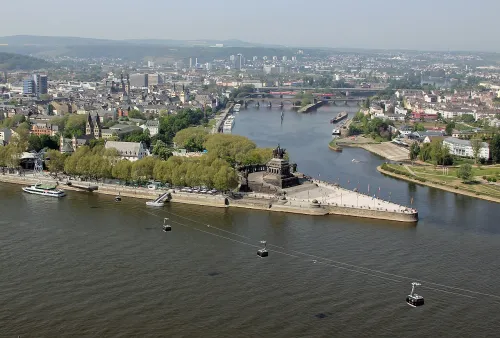
Free Walking Tour Koblenz: Old Town to Ehrenbreitstein

Start where the Mosel meets the Rhine, wander the old-town squares, then cross to Ehrenbreitstein and look down on the confluence where you began.

10 Stops 9.4 km ~2 h 15 min walking
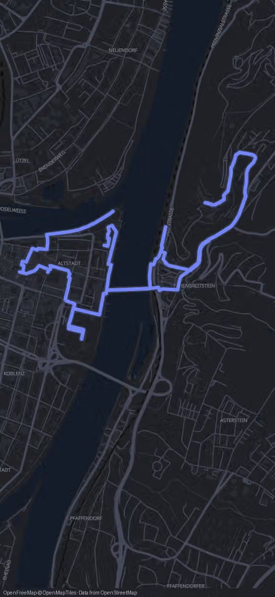
Route map for the Koblenz walking tour
Stop 1 of 10
770 m·10 min
Deutsches Eck
Head south-west off the point toward the Florinsmarkt
Hallo, welcome to Koblenz. I'm Alex, and the city's cheekiest local character is a small bronze boy with terrible manners.
Try this tour with Alex

Koblenz on Foot at a Glance

Ten stops lead from the Deutsches Eck through the old town and across the Rhine to Festung Ehrenbreitstein, ending at Basilika St. Kastor. The route covers 9.4 km with 2 h 15 min of pure walking; with a proper visit to the fortress, plan about six hours.

Almost everything is free, the basilica included. Only the fortress charges admission, and the Seilbahn Koblenz is an optional paid ride. The Kurfürstliches Schloss is currently closed, so you see it from outside. Route, map and GPS navigation in your browser are free; the AI Tour Guide is optional.

Open free GPS & optional AI Tour Guide
View of Koblenz

The Route

Walking Map of Koblenz: Confluence, Old Town and Fortress

10 stops 9.4 km 2 h 15 min walking
Tap to load interactive map

The 10 stops along this route

  1. Deutsches Eck in Koblenz, stop 1 on the self-guided walking tour
    1Deutsches Eck
  2. Florinsmarkt in Koblenz, stop 2 on the self-guided walking tour
    2Florinsmarkt
  3. Am Plan in Koblenz, stop 3 on the self-guided walking tour
    3Am Plan
  4. Schängelbrunnen in Koblenz, stop 4 on the self-guided walking tour
    4Schängelbrunnen
  5. Jesuitenplatz in Koblenz, stop 5 on the self-guided walking tour
    5Jesuitenplatz
  6. Kurfürstliches Schloss in Koblenz, stop 6 on the self-guided walking tour
    6Kurfürstliches Schloss
  7. Seilbahn Koblenz, stop 7 on the self-guided walking tour
    7Seilbahn Koblenz
  8. Festung Ehrenbreitstein in Koblenz, stop 8 on the self-guided walking tour
    8Festung Ehrenbreitstein
  9. Rheinanlagen in Koblenz, stop 9 on the self-guided walking tour
    9Rheinanlagen
  10. Basilika St. Kastor in Koblenz, stop 10 on the self-guided walking tour
    10Basilika St. Kastor
  11. That's the full route.

    Walk it with an AI Tour Guide talking you through every one of these streets.

    Start free in your browser
    You made it

Your Koblenz Walking Tour, Stop by Stop, From the Deutsches Eck to St. Kastor

  1. 1

    Deutsches Eck

    Deutsches Eck in Koblenz, stop 1 on the self-guided walking tour

    You start where two rivers become one. The Deutsches Eck is the promontory where the Mosel flows into the Rhine, and on its tip a monumental equestrian statue of William I, the first German Emperor, rides above a massive plinth. The name sounds patriotic, yet it is older than the monument: “German Corner” goes back to the Teutonic Order, whose local commandry stood here.

    In 1216 the Archbishop of Trier called the Teutonic Knights to Koblenz and gave them estates around the church of St. Kastor at the confluence. The knights worked mainly in nursing care and soon set up a commandry, the seat of the Koblenz bailiwick, answering directly to the Grand Master. From 1279 their buildings grew around the Deutschherrenhaus, and the whole complex became known as the Deutsches Eck. Around 1600 the commander moved his seat down the Rhine to Cologne. French revolutionary troops took the left bank in 1794, church property was secularised from 1802, and the Prussians later folded the premises into their Koblenz Fortress. Only in the 19th century did a pier link the spot with a sandbank downstream, creating the promontory you stand on.

    The statue tells a second story. After William I died in 1888, his grandson William II set out to build a nationalist cult around the “founder of the German Reich”, and monuments to the old emperor rose across the Prussian Rhine Province. This one was dedicated in 1897 in recognition of his role in unifying Germany. Right after the Second World War the French military government had it taken down; only the plinth stayed, as a memorial. After reunification, and after heated debate, a replica went back onto the pedestal in 1993.

    The promontory is open at all hours and costs nothing, so linger at the meeting of the waters as long as you like. Then turn your back on the rivers: 760 m, about 11 minutes, lead you into the old town to the Florinsmarkt.
    Local name
    Kaiser-Wilhelm-Denkmal am Deutschen Eck
    Hours
    Freely accessible, no opening hours
    Price
    Free
  2. 2

    Florinsmarkt

    Florinsmarkt in Koblenz, stop 2 on the self-guided walking tour

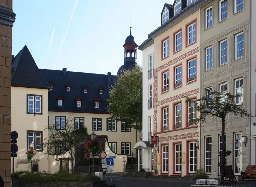
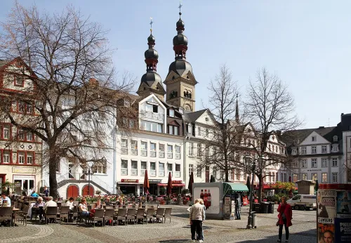
    The river landscape gives way to old-town streets, and the Florinsmarkt is their heart. Three buildings frame the square: the Florinskirche, the Altes Kaufhaus and the Bürresheimer Hof. Take a slow turn and look at the three facades side by side. There is nothing to buy and no ticket to weigh up, and that is exactly the charm of this square.

    Keep the Florinskirche in mind. It is one of the three Romanesque churches that shape the Koblenz skyline, and you will meet the oldest of the three at the very end of the walk. From here it is just 300 m, about 4 minutes, to Am Plan.

    Hours
    Freely accessible, no opening hours
    Price
    Free
  3. 3

    Am Plan

    Am Plan in Koblenz, stop 3 on the self-guided walking tour

    Am Plan is a market square with a classicist fountain from 1806 at its centre. Look at it as more than decoration: together with the obelisk on Deinhardplatz and the Kastorbrunnen, which you will see at the finish, it is one of the last surviving witnesses of Koblenz's early public water supply.

    This is also the practical stop of the old town. The covered market hall on the square trades Monday to Saturday, so if you want a market snack for the road, this is the dependable address. The open-air weekly market is a different thing and sets up on Jesuitenplatz, two stops on.

    Next you walk 280 m, about 4 minutes, to the Schängelbrunnen.

    Hours
    Freely accessible, no opening hours
    Price
    Free
  4. 4

    Schängelbrunnen

    Schängelbrunnen in Koblenz, stop 4 on the self-guided walking tour

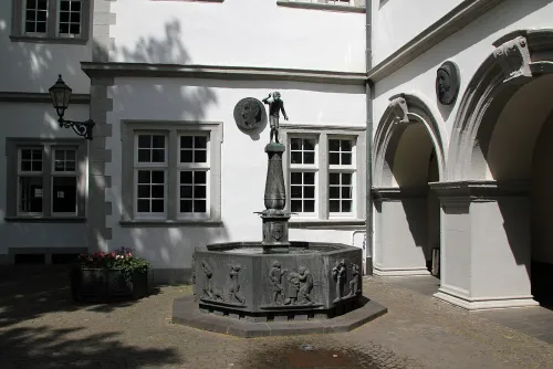
    Walk into the courtyard of the town hall, today called Willi-Hörter-Platz, and you find the Schängelbrunnen, ringed by Renaissance and Baroque buildings. It has stood here since 1941 and is one of the city's landmarks: a monument to the Koblenz Schängel, the local rascal, and his pranks, and to the high spirits of the people of Koblenz. Look closely at the octagonal basin of Eifel basalt lava. Its reliefs show the boys' tricks one by one, and the bronze figure on top is the one everybody photographs.

    Who started it is disputed. One version credits Wilhelm Smits, head of the city's cultural office, another a group of citizens including the carnival figure Jupp Flohr. The Mayen sculptor Carl Burger designed the fountain in 1939, and the bronze was cast in Munich around the turn of 1939 and 1940. In summer 1940 the dialect poet Josef Cornelius, who wrote the Schängel song, sat as a model in Burger's studio for one of the reliefs on the column.

    The foundation stone was laid on 29 October 1940, and by 6 June 1941 the work was done. Mayor Otto Wittgen, who had pushed hard for the monument, died before the handover, so his successor Nikolaus Simmer opened it on 15 June 1941. Cornelius, then 92 and the man the fountain is dedicated to, was there in person. The figure escaped both the wartime metal collections and major war damage.

    It is free and always open; give the reliefs a few minutes, they reward a close look. Jesuitenplatz is only 70 m away, a one-minute walk.

    Hours
    Freely accessible, no opening hours
    Price
    Free
  5. 5

    Jesuitenplatz

    Jesuitenplatz in Koblenz, stop 5 on the self-guided walking tour

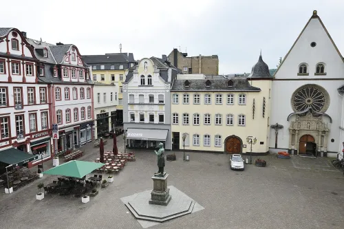
    Jesuitenplatz works as the old town's living room. The grand building on the square is the former Jesuit college, today the town hall, and in front of it stands the Johannes-Müller monument.

    The real reason to plan your day around this square is the weekly market. On Tuesday, Thursday and Saturday mornings it fills with fishmongers, bakers and wine stalls, the most locally rooted scene of the whole route. Come on a Friday and you find an empty square, so if the market matters to you, let it choose the day of your walk.

    From here the route leaves the tight lanes behind and heads 840 m, about 11 minutes, to the Kurfürstliches Schloss.

    Hours
    Freely accessible, no opening hours
    Price
    Free
  6. 6

    Kurfürstliches Schloss

    Kurfürstliches Schloss in Koblenz, stop 6 on the self-guided walking tour

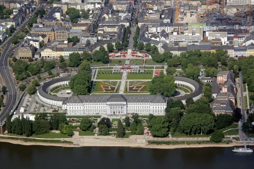
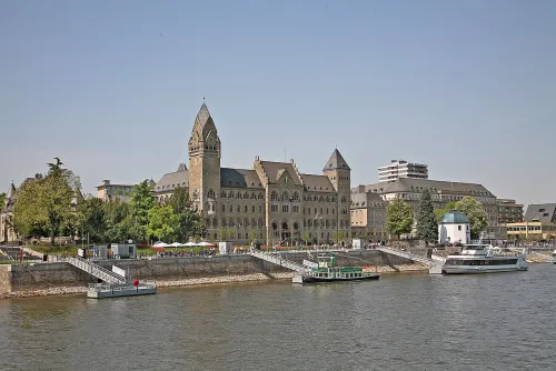
    The Kurfürstliches Schloss is currently closed, so this is a stop for the outside. It was built in the late 18th century for Clemens Wenceslaus of Saxony, the last Archbishop and Elector of Trier, and today it houses federal government offices.

    What you look at is a deliberate break with the past. Clemens Wenceslaus hired French architects and got a fairly plain, austere building in early French neoclassical style instead of the Baroque that Koblenz had known until then. It counts among the most important examples of this style in southwestern Germany and was one of the last palaces built in Germany before the French Revolution.

    Read the layout: a long rectangular main building runs parallel to the Rhine, and two semicircular wings reach out towards the city, framing the large forecourt. On the city side a portico of eight columns rises to the roofline. On the river side, six columns carry a relief by Sebastian Pfaff showing the Rhine and the Mosel as allegories, the electoral coat of arms and lions standing for sovereignty. The side wings were rebuilt in the 1950s, two storeys high.

    There is a link back to your first stop: in the mid-19th century the Prussian crown prince, later Emperor William I, had his official residence here as military governor of the Rhine Province and Westphalia. From the Schloss you walk 1620 m, about 22 minutes, to the Seilbahn Koblenz.

    Status
    Currently closed
  7. 7

    Seilbahn Koblenz

    Seilbahn Koblenz, stop 7 on the self-guided walking tour

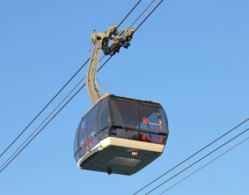
    The Seilbahn Koblenz swings across the Rhine, linking the Rheinanlagen near Basilika St. Kastor with the plateau in front of the fortress. It was built as an attraction and an environmentally friendly connection for the 2011 Federal Garden Show and has been running since June 2010. It was Germany's first tricable gondola, and with 7,600 passengers an hour, 3,800 in each direction, it has the largest capacity in the country. Building it cost around twelve million euros.

    Its existence was never a given. Planners faced the same problem Cologne had solved with a cable car for its 1957 garden show: how to link show areas far apart, here on the left bank and up on Ehrenbreitstein. A bus shuttle was on the table, but the better environmental balance of a cable car won. In November 2008 the contract went to the Austrian company Doppelmayr, which was to build it, run it and take it down again in November 2013, because dismantling seemed necessary to protect the UNESCO status of the Upper Middle Rhine Valley. The cable car stayed. Its permit originally ran until the end of 2026; with UNESCO's consent it may now operate until at least 2030. A Doppelmayr subsidiary runs it and uses it as a showcase.

    The ride costs extra, with reduced fares for pupils, students and children. Ride it if you want to float over the Rhine and save your legs for the fortress. If you prefer to walk, the route to Festung Ehrenbreitstein is 2300 m, about 37 minutes.

    Hours
    Daily: 10:00–19:00
    Price
    15.50 EUR round trip adults, 15.00 EUR reduced, 8.50 EUR pupils/students, 7.00 EUR children (7-17 years)
  8. 8

    Festung Ehrenbreitstein

    Festung Ehrenbreitstein in Koblenz, stop 8 on the self-guided walking tour

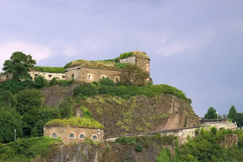
    Festung Ehrenbreitstein stands on the east bank of the Rhine, opposite the mouth of the Mosel, on a hill 118 m above the river, and from up here you look down on the confluence where you began. Prussia built the fortress between 1817 and 1828 as the backbone of the Koblenz fortification system, to guard a middle Rhine region that French troops had invaded again and again. It replaced an earlier fortress the French destroyed in 1801, and the Prussian one was never attacked.

    The hill is far older than its walls. People settled here in the 4th millennium BC and built fortifications in the 10th and 9th centuries BC; a Roman fort followed between the 3rd and 5th centuries AD, then Carolingian settlement. Around the year 1000 a noble called Ehrenbert put a castle up here, and Burg Ehrenbertstein slowly became Ehrenbreitstein. In 1139 it appears in writing as property of the Archbishop of Trier, and later archbishops kept enlarging it, adding a support castle, Burg Helferstein, on the neighbouring hill.

    In the 16th century work began to turn the castle into a fortress fit for gunpowder weapons. One of its first cannons was the Greif of 1524, weighing 9 tons. At the foot of the hill, protected by the fortress, Philipp Christoph von Sötern built the Philippsburg palace between 1625 and 1629. Since 2002 Ehrenbreitstein has been part of the Upper Middle Rhine Valley World Heritage Site, and it marks its northernmost point.

    The fortress charges admission, and if you pay for only one thing on this walk, make it this one; give it about two hours. Afterwards the route leads 2740 m, about 37 minutes, back down to the Rheinanlagen, or you ride the Seilbahn down and get off in the Rheinanlagen near the basilica.

    Hours
    Summer season (end of March – early Nov): daily 10:00–18:00; winter season (Nov–March): daily 11:00–16:00
    Price
    10 EUR
  9. 9

    Rheinanlagen

    Rheinanlagen in Koblenz, stop 9 on the self-guided walking tour

    The Rheinanlagen are a 3.5 km park with a promenade along the left bank of the Rhine. They begin at the Deutsches Eck, run as the Konrad-Adenauer-Ufer for about 1 km to the level of Stresemannstraße and continue as the older Kaiserin-Augusta-Anlagen for about 2 km to Mozartstraße. You see only a short piece of them on this walk, so treat it as a breather by the water after the fortress.

    The older part is the work of Peter Lenné, who laid it out between 1856 and 1861 as an English landscape garden for Princess Augusta, wife of the later Emperor William, the same man who rides at the Deutsches Eck and once lived in the Kurfürstliches Schloss. Back then the park ran downriver only as far as the city wall in front of the Schloss. When the walls came down in 1902, the stretch between the Schloss and the Deutsches Eck was built as a promenade; in January 1976 it was named after Konrad Adenauer for his work in restoring German democracy.

    Air raids in the Second World War wrecked the park and much of its lavish furnishings. It was rebuilt in the 1950s, redesigned in the 1970s and restored once more for the 2011 Federal Garden Show. From here it is 540 m, about 7 minutes, to the last stop, and on the way you pass the Ludwig Museum Koblenz before you reach Basilika St. Kastor.

    Hours
    Freely accessible, no opening hours
    Price
    Free
  10. 10

    Basilika St. Kastor

    Basilika St. Kastor in Koblenz, stop 10 on the self-guided walking tour

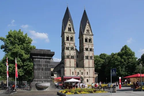
    Basilika St. Kastor is the oldest church in Koblenz, the oldest of the three Romanesque churches you heard about at the Florinsmarkt, and it stands near the Deutsches Eck, so the walk ends a short way from where it began. This is the church around which the Teutonic Knights received their estates. In front of it stands the Kastorbrunnen, built in 1812 during Napoleon's invasion of Russia, the last of the old water-supply fountains you met at Am Plan.

    Archbishop Hetto of Trier built the church between 817 and 836 with the support of Emperor Louis the Pious, just outside Confluentes, the town the Romans had founded here, and it was consecrated on 12 November 836. Because Koblenz had a Frankish royal court, it was a Carolingian proprietary church under Louis, yet he only came to Koblenz after the consecration, which shows how much the archbishop drove the project. The church stood outside the city until the 13th century, and later in the 9th century it gained a transept with a semicircular apse.

    The church honours Saint Castor, said to have worked as a missionary on the Mosel in the 4th century and to have founded a religious community in Karden. Look for the shrine of Rizza, said to be a daughter of Louis the Pious, who is venerated here as a saint of Koblenz. In 1991 Pope John Paul II raised the church to a minor basilica.

    Go inside: entry is free, and the Romanesque building with its largely traditional furnishings is the reason to come. When you are done, the GPS navigation can guide you back to the Deutsches Eck if you want to close the circle.

    Hours
    Apr–Oct: Daily 09:00–18:00 | Nov–Mar: Daily 10:00–16:00
    Price
    0 EUR
Walking tour route map of Koblenz Route loaded
Deutsches EckFlorinsmarktAm PlanSchängelbrunnen+6
All 10 stops are already on the map.
You just press start.
AI Tour Guide

You know the route now. Walk it with a guide in your ear.

Press start wherever you are, even hundreds of kilometres from Koblenz, and the guide begins telling its stories right away. In the city, pick any of the 10 stops to start from: it leads you there, then talks with you the whole route, asking, listening, remembering, and shaping the tour around your answers.

10stops 9.4km 2 h 15 minwalking 13languages
▶Start the tour free

Free to start · Runs in your browser · No app, no download

Shorter Ways to See Koblenz

The full route fills most of a day. If you have less time or want to spare your legs, pick one of these.

Old town only

Stops: 1, 2, 3, 4, 5

For a morning or a stopover: from the Deutsches Eck through the Florinsmarkt, Am Plan and the Schängelbrunnen to Jesuitenplatz. About 1.4 km and 20 minutes of walking, and all of it free. Best on a Tuesday, Thursday or Saturday morning, when the weekly market is on.

Up and down by cable car

Stops: 1, 2, 3, 4, 5, 6, 7, 8, 9, 10

All ten stops, but you ride the Seilbahn up to the fortress and back down to the Rheinanlagen instead of walking those two legs. Your walking time drops to about one hour. You pay for the cable car round trip and the fortress admission; everything else stays free.

How Long Does the Koblenz Tour Take With the Fortress?

The old-town squares come thick and fast: from the Deutsches Eck to Jesuitenplatz you walk only 20 minutes in total. The long legs come later, 22 minutes from the Kurfürstliches Schloss to the Seilbahn, then 37 minutes each up to the fortress and back down to the Rheinanlagen. Altogether that is 2 h 15 min of pure walking.

Realistically, plan about six hours. Start at 10:00 at the Deutsches Eck, take short breaks in the old town, and you reach the Seilbahn around noon and the fortress at about 12:35. Give Ehrenbreitstein two hours, walk down, spend twenty minutes in the Rheinanlagen, and you stand at Basilika St. Kastor around 15:40.

The old-town version takes about an hour and a quarter. With the cable car up and down you save 74 minutes of walking, so the whole route then fits into a little over five hours.

Before You Set Off from the Rivers' Meeting Point

  • Start and finish: The recommended start is the Deutsches Eck, but you can join at any stop. The route ends at Basilika St. Kastor, close to where you began, and the GPS navigation leads you back to the start if you like.
  • Best day and time: Tuesday, Thursday or Saturday, starting around 10:00, so you catch the weekly market on Jesuitenplatz. Start early enough to leave time for both the fortress and the basilica.
  • Costs: Only two things cost money: Festung Ehrenbreitstein and, if you choose to ride it, the cable car. The squares, the riverside park and the basilica are free.
Walking tour route map of Koblenz
AI Tour Guide

Your guide is ready when you are, at any stop.

Press start and a voice AI Tour Guide takes it from here: leading the route through Koblenz, telling the stories, and turning your walk into a real back-and-forth conversation. No app or download is needed; it runs in your browser.

10stops 9.4km 2 h 15 minwalking 13languages
▶Start the tour free

Free to start · Runs in your browser · No app, no download

What the AI Tour Guide Adds Between Rhine and Mosel

Koblenz is a city of threads that run across the whole day, from the emperor on his horse to the fountains of the old water supply. The AI Tour Guide greets you at the start, tells the stories as you walk, asks what draws you in and follows that, so a question about the Teutonic Knights' nursing work or about daily life in the Prussian garrison on the plateau becomes part of the tour. You start with 100 free credits; after that, unlock this tour all-inclusive for €19.99 with no time limit, or pay €5 per hour.

A Real Conversation A voice AI Tour Guide greets you, leads the whole route, and tells the stories and facts as you walk, asking what you want to see and keeping a real conversation going. Not a recording you press play on.
Map Navigation Follow the route on the map and walk at your own pace. You choose where to start and when to move to the next stop.
Ask Anything Curious about a building you pass? Ask your AI Tour Guide on the spot and the conversation carries on.
13 Languages Switch language anytime. No separate tour needed.
Start free in your browser

Common Questions About Walking Koblenz

Can I combine Koblenz with another city on the same trip?

Yes. Bonn is 54 km away, Mainz 63 km and Trier 96 km, and each has its own free walking route.

Does the walk work on a Sunday?

For the sights, yes: the outdoor stops are always open, and the fortress, the cable car and the basilica open daily. You miss both markets, though, since the hall at Am Plan trades Monday to Saturday and the weekly market runs only on three mornings.

Is the route worth walking in December?

Yes. The Christmas market spreads across seven squares, the Florinsmarkt among them, so the old-town part of the walk becomes a stroll through the stalls, and the town hall facade on Jesuitenplatz turns into a giant advent calendar. Keep the early winter closing of the fortress and the basilica in mind.

Is the tour really free?

Yes. The whole tour is free: the route, the interactive map and the navigation cost you nothing. Only the voice AI Tour Guide is optional and paid: you test it with 100 free credits, then you pay either €5 per hour or €19.99 for this whole tour, with no time limit. Admission to one of the 10 stops is not included: Festung Ehrenbreitstein charges its own entry fee.

Do I need to download an app?

No. Everything runs in your phone browser. Open the route and start walking, no download and no sign-up required.

Do I need to book the walking tour in advance?

No booking needed. This self-guided tour is available anytime. Open the route in your browser and start walking. The AI Tour Guide works instantly, no app, no reservation required.

What languages is the AI Tour Guide available in?

The AI Tour Guide speaks 13 languages, so you take the tour in your own language and can switch at any time.

Can I skip stops or change the route?

Yes. Skip any stop, spend extra time at places you like, or start the route from any point. It is your walk, you set the pace.
Image credits
▶ Start free in your browser Runs in your browser, no app, no download